Brief Introduction of Xiangxi UNESCO Global Geopark
In the hinterland of the Wuling Mountain in Xiangxi Tujia and Miao Autonomous Prefecture (Hunan Province), Xiangxi Global Geopark bears witness to a rich human history starting in the Paleolithic age and features 160 cultural sites from the Paleolithic and Neolithic ages. The area is now mainly inhabited by Tujia and Miao ethnic minorities, the earliest indigenous people living in Xiangxi Prefecture, whose rich history and culture have given rise to unique folk customs. The geology of the area records the forming of the Yangtze Platform, a foreland basin that has undergone multiple stages of tectonic evolution. In the geopark, the Cambrian system is particularly visible, with two sites of high international importance. The area is also known for its Red Stone Forest, the Dehang Grand Canyon, the Zuolong Valley, and many spectacular waterfalls. More detailed information on Xiangxi Global Geopark is provided at: http://www.xiangxigeopark.com/en/

Photo 1. The red stone forest in Xiangxi UGGp
Brief Introductopn of Zhangye UNESCO Global Geopark
Zhangye Global Geopark is located in Zhangye City, Gansu Province, which was an important township on the ancient Silk Road, trade route between China and the West. The geopark’s 577 cultural sites bear witness to the history of the city that is home to a number of minority ethnic groups, including Yugurs, with distinct cultures and lifestyles. The most notable feature of the Geopark is the presence of colourful hills, the best example of China’s Danxia landform, formed by folded sandstones in different colours. Some of the hills have been eroded creating ‘window-lattice’ and ‘palace-style’ landforms. Another important feature is the ‘Nine-Springs’ ophiolite, a remnant of the ancient oceanic crust, which has been studied by multiple geologists for its international geological significance. More detailed information on Zhangye Global Geopark is provided at:
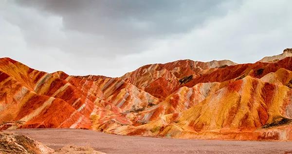
Photo 2. The multi-color landscape in Zhangye UGGp